Treasure Island
The Fulton Theatre set sail for its 2018-2019 season with Treasure Island on September 18, 2018. If you joined LancasterHistory.org for Thirsty for History Thursday at the Fulton on Thursday, September 27, you would have been regaled with plethora of historical information, tying Lancaster County’s history with elements, themes, and motifs from Treasure Island. If you missed it, now is your chance to catch up on what you missed!
Hoist your sails! Let’s go…
Islands
The Susquehanna River is home to plenty of islands:
- Shelley’s Island: Shelley’s Island is technically now part of Dauphin County, but was part of Lancaster County until 1785. It’s a little over 200 acres and was owned by Daniel Shelley during the Revolutionary War. Shelley, along with several compatriots, plotted to destroy local stores of ammunition to aid the British. Shelley’s plan was discovered and he fled the island, only to be jailed at Carlisle. The island was later used by the Girl Scouts and the kids of St. James Episcopal Church choir as a summer camp.
- Hill Island: Hill Island is also now part of Dauphin County, near Shelley’s Island. In 1844 a religious sect known as the Millerites – followers of William Miller, a baptist lay minister from New York – holed up on the island to await the end of the world and the second coming of Christ. Wearing only white robes, the group waited patiently only to be sadly disappointed when Jesus didn’t show up and the world kept going on.
- Three Mile Island: Once owned by Thomas Cookson (c. 1749) and later by Col. James Duffy of Marietta in the late 1800s, this island was once known as Greenawalt’s Island. It gained notoriety on March 28, 1979 when a partial meltdown of reactor unit two at the nuclear power plant sent the area into a well-justified panic.
- Scylla Isle and Charybdis Isle: Located off the shores of Conoy Township, they were named for the mythological monstrous rock (Scylla) on the island of Sicily, and the notorious whirlpool just off its coast (Charybdis). Apparently the waters were a bit rough in this part of the river.
- Galbraith’s Island: Not far from Bainbridge, Conoy Township. Described when it was for sale in 1814 as such: 125 acres with a two story log structure 36 by 40 feet in size, well finished with a well of never-failing water near the door. This island affords a sufficiency of drift timber to supply a distillery constantly with fuel. It has three excellent fisheries with seines and boats belonging to them. [From the Marietta Pilot, January 18, 1814.]
- The Isles of Promise: Off of Washington Boro. Owned first by Thomas Cresap – they were granted to him by the Proprietor of Maryland. Later sold by Cresap to Michael Atkinson in 1758. By 1857 they were property of the late Abram Bitner of Washington Boro. At the time of his death the Isles consisted of nine islands: House Island, Big Island, Sheep Island, Middle Island, Potato Island, Muskrat Island, Spice Island and two that were unnamed. All were tillable and had some sort of structures on them.
- Mount Johnson Island: Named for its colonial era owner, Thomas Johnson. Located below Fishing Creek off the shores of Drumore Township. Johnson was the father-in-law of pesky Marylander Thomas Cresap. The 75 acre island was claimed by Maryland during Cresap’s War. It’s now home to the first bald eagle sanctuary in the world.
- Baker’s Island: Baker’s Island was patented to Christian and Barbara Herr in 1795 and later sold to Samuel Smith in 1813. The next few decades go something like this:
- Bought from the estate of Samuel Smith in 1838 by Benjamin Hammond and David Lee
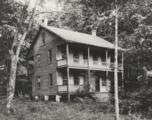
The lovely, two story frame cabin on Baker’s Island in 1907. - Sold by Lee to Jacob Shoff in 1849
- Sold by Shoff to Clarkson and Catharine Bostick in 1878
- In 1879, the island was bought by William Miller and Anthony Lechler for the use of the Sicily Island Fishing Club. They paid $160 for it. At this point it’s still called Cove Island, and is still listed as Cove Island on the 1899 Atlas. The island encompasses 4 acres and 80 perches and is located about 50 yards off the shore of Drumore Township near Fite’s Eddy.
- In 1907 it’s called Baker’s Island and there is a lovely two story frame cabin on t
- he island. On July 10, 1907 crews are laying tracks for the Columbia and Port Deposit Railroad. They blast some rocks away near Fite’s Eddy. The blast is so strong, it knocks over the cabin on Baker’s Island/Cove Island/Sicily Island.
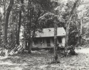
The same two story cabin after a particularly strong rock blast.
- Bought from the estate of Samuel Smith in 1838 by Benjamin Hammond and David Lee
Buried Treasure
Where and how to find the best buried treasure:
- Money Rocks – Now a County Park, Money Rocks is located in the famed Welsh Mountains where Caernarvon, East Earl and Salisbury Townships meet. Several legends seem to abound about the area’s name. One suggests that during the Civil War, local farmers hid their money and other valuables in the hills from the advancing Confederates. Others say that the notorious Abe Buzzard and his band of thieving brothers had a hideout and hid their loot in the hills. Either way, the area now makes for an interesting hike.
- California – California–in this case–is a small village, almost non-existent these days, located west of Churchtown in Caernarvon Twp. No one is sure how it got its name. Perhaps from the notion that there may be gold in ‘them thar’ Welsh Mountains. Some think there was some sort of treasure buried on a farm in the area. A simpler reason may be that it took its name during the gold rush days of the late 1840s and early 1850s.
- Buried treasure – many superstitions abound when it comes to digging for buried treasure in Lancaster County. It’s unclear if these notions are rooted in Pennsylvania Dutch culture or Scots-Irish lore, but they’re definitely interesting. For instance, digging for any treasure must be done at night. No talking is allowed for fear that the treasure will disappear. Salt is to be scattered around the digging site to protect against witches and carrying a coffin nail will ward off evil spirits.
- Mining – Locals believe that some of the area creeks are just right for prospecting. Peters Creek in Fulton Twp. is one of the best for panning, as are the streams around the old Cornwall Furnace just over the Lebanon County border. There is also the old Pequea Silver Mine in Pequea Twp. Possibly mined early on by local Native Americans, the mine was worked off and on as recently as the 1930s – a period of about 250 years.
Gold Rush Guys
A selection of brave, adventurous, and –quite possibly–foolhardy men who ventured west in search of gold, silver, and whatever riches they could find.
- Hosea Ballou Grosh and his brother Ethan Allen Grosh, discoverers of the Comstock Lode in the Virginia Range in Nevada. Hosea was born August 23, 1826 and Ethan was born November 7, 1824 – both in Marietta to minister Aaron B. Grosh. The lode was discovered in 1857, but both brothers died before they could lay claim to it. Hosea Grosh injured his foot and died of septicemia in September of 1857 in Nevada. Ethan Allen Grosh entrusted their belongings to Henry Comstock, a fellow miner, while he went off to California to raise funds to file the claim. Ethan Allen Grosh died, in of all places, a town called Last Chance, in Placer County, California, deep in the Sierra Nevada Mountains in December 1857. He never made it to Sacramento to file his claim. Henry Comstock took their claim and went down in history as the famous finder of the first major vein of silver in the United States.
- David Baer Hackman was born in Manheim in 1827 and left for California in the fall of 1849. In the spring of 1850 he took a steamboat from Cincinnati to St. Louis and then made the arduous journey by wagon train to California. He arrived in California in the fall of 1850. Hackman later moved south to Yankee Hill, near Columbia, California. It would take three years of hard work before he saw his best day of mining. Hackman would spend another year in the gold mines before returning to Pennsylvania via steamer from San Francisco, train over the Panama isthmus and another steamer to New York. He returned to Manheim, ran a store, married twice and died in 1896. Hackman’s letters to his family and his journal kept while in California are found in MG-72, David B. Hackman Collection, in LancasterHistory.org’s archives.
- Paris Haldeman, brother of Samuel S. Haldeman, arrived in Sacramento, California, on September 5, 1849. Ten days later he wrote to his mother, describing his journey and the city of Sacramento, saying that town had a population of about 7,000, had much gambling and was generally good for business. He also mentioned “Capt. Sutter” and heading to Carson River (east of Sacramento in the Sierra Nevadas) and Yuba City (just north of Sacramento). By October 28, 1849, he made it to “Reading’s Diggings”, which I believe means somewhere near Redding, California, about 200 miles north of Sacramento. Paris Haldeman was born in 1831 and died in 1893. This letter and few others are part of MG-736, Haldeman Family Papers and Business Records, in our archives.
- And let’s not forget John Augustus Sutter. He was born in 1803 in Switzerland. Arrived in California in 1839. Established Fort Sutter and Sutter’s Mill, both now pretty much Sacramento. Gold was discovered on his land and this precipitated the big gold rush of 1849. Although he tried to keep the gold discovery quiet, word got out and his land was overrun with prospectors. A series of bad land disputes left him in financial distress. He settled in Lititz in 1871 and began appealing to Congress to reimburse him for his lost property in California. He died in Washington, DC, in 1880, waiting to find out about reimbursement. He’s buried in the Moravian Cemetery in Lititz. The General Sutter House is located at 17 – 19 Main Street in Lititz.
- Joshua Scott, surveyor and mapmaker. He was born around 1775 in England, and may have arrived in Lancaster around 1805. Tax lists record him as a surveyor by occupation. He owned property on the 400 block of East King Street, about where Snyder’s Funeral Home is now located. He got his start drawing property draughts for deeds or other public records and surveying and drawing plot maps for various local land developers. For example, someone wanted to develop a town called Blue Rock in Manor Township and Joshua Scott took the task of surveying and mapping it, but the town never happened. He is also thought to have given Paradise its name. As legend goes, the town was called Pequea Village, but he looked around and said that it looked like Paradise. And it stuck. His first big map making endeavor was for the Hamilton estate, which required a plot map of the borough of Lancaster in 1817. In 1819, he created his first map of Lancaster County. It was mostly for government purposes, so he decided to create a map of the county for the public. This map for the public was published in 1824. Improvements and updates were published in 1842, 1851, 1858 and 1860. The last three were done posthumously. It’s thought that Scott returned to England, where he died in 1850.
- The Pirates, “an association of honorable gentlemen”. Motto: Footloose and Fancy Free. Around 1905, Harry S. Williamson and his circle of friends gathered regularly for fishing trips along the Susquehanna River. The trips were usually followed by lively dinners and rather vociferous singing. These dinners evolved into the Susquehanna Shad Choir Club. Shad being the most plentiful fish in the river at the moment, and the choir from all the rowdy singing seemed to lend itself to the name of the new group. The Shad Choir Club met for a dinner at Harry S. Williamson’s house – known as Upland Lawn – in 1910. It was at this dinner that the group took on its new name, The Pirates, and Harry S. Williamson became its first Chief. Williamson was a noted businessman – he owned a department store in town – and philanthropist – Williamson Park and Williamson Field are both named in his honor. Upland Lawn no longer stands – it’s now the site of Williamson Square Apartments. According to guidelines, the Pirates hold annual meetings each January, usually at the Hamilton Club, and annual picnics each summer. In addition, the Pirates go on “cruises” – at first just fishing trips to various locations (Benton Hollow, Tucquan Glen, the Accomac, Port Deposit) and later more educational field trips (Gettysburg, Bainbridge Naval Training Center, and even the Pentagon). Members must go on at least two outings each year to maintain active membership. There are only ever 100 members in the club. Each member gets a piece of eight.
Featured image courtesy of the Fulton Theatre.
From Thirsty for History